
No-Fly Zones for FPV Drones: A Complete Guide to Restricted Airspace
Introduction: Understanding Airspace Restrictions for FPV Pilots
FPV drone flying offers an exhilarating experience that lets pilots explore the world from breathtaking perspectives. However, navigating the complex web of airspace restrictions is crucial for both safety and legal compliance. As drone technology advances and regulations evolve, understanding no-fly zones has become an essential skill for every responsible FPV pilot.
This comprehensive guide will help you identify restricted airspace, understand the regulations governing drone operations, and develop safe flying habits that protect both your equipment and public safety. Whether you're a recreational flyer or commercial operator, mastering airspace knowledge will ensure you enjoy FPV flying while respecting necessary limitations.
What Are No-Fly Zones and Why Do They Exist?
No-fly zones, also known as restricted airspace, are designated areas where drone operations are prohibited or severely limited. These restrictions exist to protect critical infrastructure, ensure public safety, prevent security breaches, and minimize conflicts with manned aircraft.
For FPV pilots, understanding these limitations is particularly important since the immersive nature of first-person view flying can sometimes make it challenging to maintain situational awareness of surrounding airspace. The consequences for violating no-fly zones can be severe, including substantial fines, equipment confiscation, and in some cases, criminal charges.
Major Categories of No-Fly Zones
Airport and Aerodrome Restrictions
One of the most critical no-fly zones exists around airports and aerodromes. According to aviation regulations, areas surrounding airports or飞行场 are typically prohibited for drone activities without special authorization. The specific distance restrictions vary by country but generally extend several kilometers from airport boundaries.
In the United States, airport restrictions typically extend 5 miles from runways, while other countries may have varying distances. Many modern drones include built-in geofencing systems that warn pilots when approaching these restricted areas, but relying solely on technology isn't sufficient - pilots must proactively check their locations before flying.
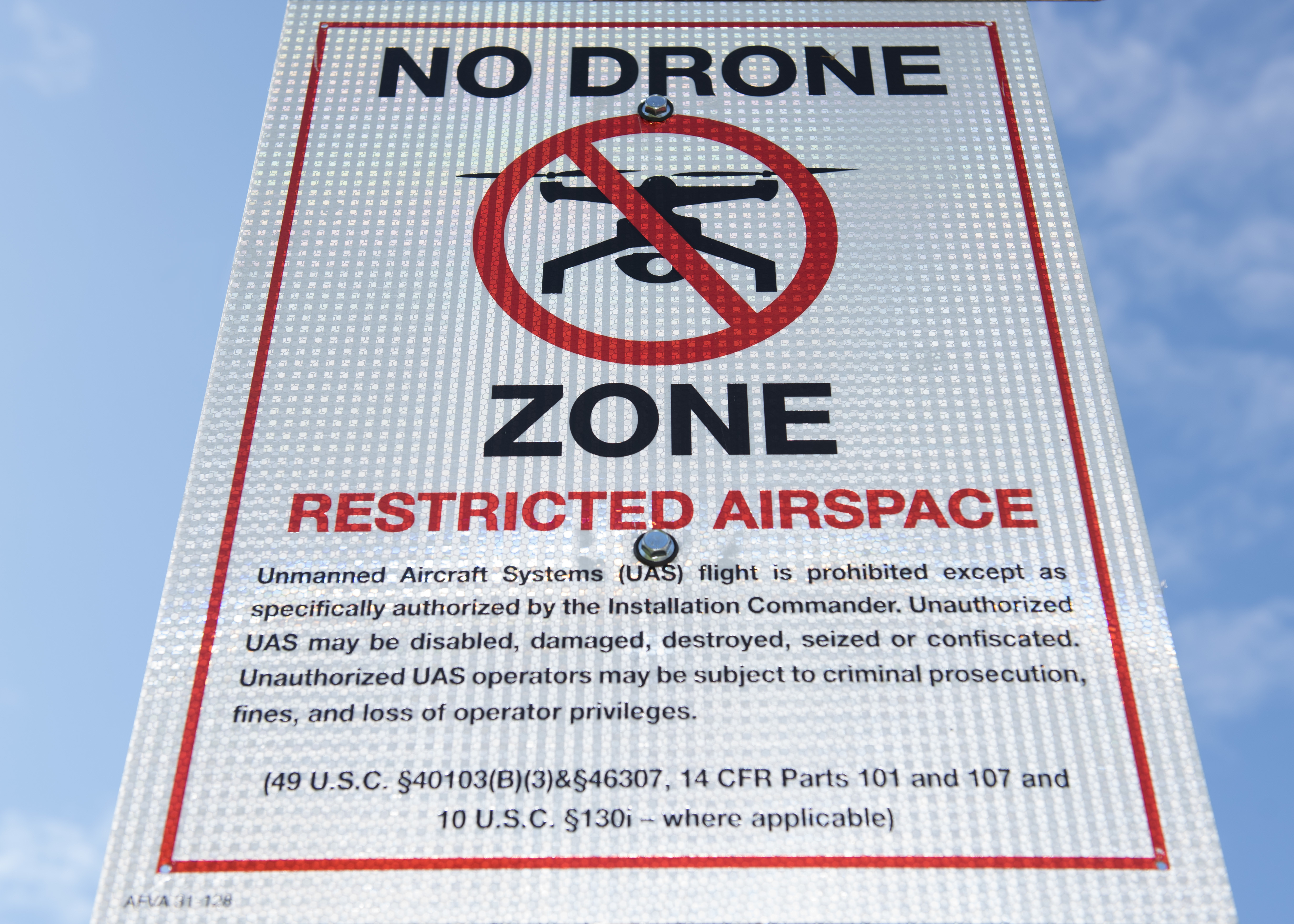
Military and Government Facilities
Military installations, government buildings, and other sensitive facilities almost always constitute no-fly zones for drones. These restrictions protect national security interests and prevent potential surveillance threats. The exact boundaries are often not publicly detailed for security reasons, so pilots must exercise extreme caution and research thoroughly before flying near any government-related facilities.
Critical Infrastructure Sites
Important infrastructure facilities represent another category of restricted airspace. These include:
• Power plants and electrical substations
• Water treatment facilities
• Communications infrastructure
• Transportation hubs
• Industrial facilities
These restrictions prevent both accidental damage and intentional threats to essential services. For example, regulations specifically prohibit flying within five hundred feet of any water intake facility or electric generating facility without the owner's consent.
Emergency Response Areas
When emergency services are responding to incidents, temporary no-fly zones are often established around these areas. Regulations typically prohibit flying within four hundred feet of any emergency response operation. This ensures that emergency personnel can work without interference and that drone operations don't compromise rescue or recovery efforts.
Special Event Locations
Large public gatherings such as sporting events, concerts, festivals, and political rallies often establish temporary flight restrictions (TFRs). These restrictions may extend for specific distances and altitudes around event venues. Pilots must check for TFRs before every flight, as these temporary restrictions can be established with relatively short notice.
Protected Natural and Cultural Areas
National parks, nature reserves, historical sites, and culturally significant locations often restrict drone operations. These limitations protect wildlife, preserve tranquil environments, and maintain the integrity of historical sites. While not always legally mandated, many protected areas have specific policies prohibiting drone flights.
Understanding Altitude Restrictions
Beyond specific location-based no-fly zones, altitude restrictions represent another critical dimension of airspace regulation. In many jurisdictions, drone operations are limited to 400 feet (approximately 120 meters) above ground level without special authorization.
However, additional restrictions may apply to certain areas. For instance, some locations may impose even lower altitude limits, while others might completely prohibit any drone operations regardless of altitude. Pilots must understand that altitude restrictions work in conjunction with location-based limitations.
How to Identify No-Fly Zones Before You Fly
Official Government Resources and Apps
Most national aviation authorities provide official resources for identifying no-fly zones:
• FAA B4UFLY App (United States)
• NAATS Portal (United Kingdom)
• Civil Aviation Authority Websites (various countries)
These official sources provide the most accurate, up-to-date information on permanent and temporary restrictions.
Drone Manufacturer Mobile Apps
Most major drone manufacturers include airspace information within their companion apps. DJI, for instance, incorporates geofencing systems that display restricted areas and may prevent takeoff or flight into certain zones. While helpful, these shouldn't be your sole source of information as they may not include all temporary restrictions.
Third-Party Airspace Maps
Several third-party services offer detailed airspace maps specifically for drone pilots:
• Airmap
• UAV Forecast
• Kittyhawk
These platforms often aggregate information from multiple sources and provide user-friendly interfaces for checking planned flight locations.
Local Authority Guidance
In many regions, local governments have the authority to establish additional drone restrictions based on community needs. Checking with municipal authorities or local aviation offices can provide information about area-specific limitations that might not appear on national databases.
Special Authorizations and Waivers
When and How to Obtain Flight Permissions
While many areas are completely off-limits to drones, some restricted zones may allow operations with special authorization. The process for obtaining these permissions varies by jurisdiction and the type of airspace involved.
For operations in controlled airspace near airports, approval typically comes from national aviation authorities. In other restricted areas, local governments or facility managers may grant permissions. The process often involves submitting detailed flight plans, demonstrating pilot competency, and proving insurance coverage.
Commercial vs. Recreational Considerations
Commercial drone operators often have more pathways to obtaining waivers than recreational flyers, particularly when operations serve specific business or institutional purposes. However, the application process can be lengthy and requires thorough documentation of safety protocols.
International Variations in No-Fly Zone Regulations
While this guide covers general principles that apply across many jurisdictions, specific no-fly zone regulations vary significantly between countries. For example:
• United States: FAA regulations establish specific dimensions for airport flight restrictions and temporary flight restrictions.
• European Union: EASA provides a framework that member states implement with local variations.
• United Kingdom: The CAA designates specific restricted areas beyond the standard airport boundaries.
• Canada: Transport Canada establishes regulations with particular emphasis on built-up areas.
• Australia: CASA regulations include specific distance requirements from people and buildings.
FPV pilots traveling internationally must research destination-specific regulations before flying. Assuming that rules are similar to your home country can lead to serious legal complications.
Technological Solutions for Airspace Awareness
Geofencing Systems
Many modern FPV systems incorporate geofencing technology that uses GPS data to identify restricted airspace. These systems may provide warnings or actively prevent entry into no-fly zones. While helpful, pilots should not rely exclusively on these systems, as they may not include all temporary restrictions or local regulations.
ADS-B and Other Awareness Technologies
Some advanced drone systems incorporate Aircraft Detection Systems-Broadcast (ADS-B) receivers that display nearby manned aircraft. This technology enhances situational awareness and helps prevent conflicts in shared airspace, particularly near airports or in other high-traffic areas.
Best Practices for FPV No-Fly Zone Compliance
Pre-Flight Checklist for Airspace Verification
Develop a consistent pre-flight routine that includes:
1. Checking official airspace maps for your planned location
2. Reviewing temporary flight restrictions (TFRs)
3. Verifying local regulations and municipal restrictions
4. Ensuring your equipment and software are updated with latest airspace data
5. Having a backup location identified in case your primary site proves unsuitable
In-Flight Vigilance
Even with thorough pre-flight planning, remain vigilant during operations:
• Maintain visual line of sight where required
• Monitor for unexpected aircraft
• Be prepared to land immediately if unauthorized aircraft enter your operating area
• Watch for changing conditions that might necessitate ending your flight early
{{ commentCount }} Comments