
Latest Drone Technology 2025: 10 Breakthroughs Revolutionizing UAVs
The drone industry is soaring to new heights in 2025, fueled by groundbreaking advancements in artificial intelligence, sensor technology, and materials science. From drones that navigate complex environments without human intervention to specialized systems capable of handling extreme山地conditions, the latest innovations are transforming what's possible with unmanned aerial vehicles. This comprehensive guide explores the most significant technological breakthroughs of 2025, showcasing how they're expanding applications across industries from emergency response to urban management and beyond.
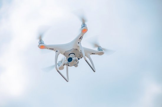
1. AI-Powered Autonomous Navigation Systems
Artificial intelligence has become the cornerstone of modern drone technology, enabling unprecedented levels of autonomy and decision-making capability. Unlike traditional drones that rely heavily on GPS and human pilots, 2025's most advanced systems can perceive, interpret, and navigate complex environments independently.
The DARPA Fast Lightweight Autonomy (FLA) program has demonstrated quadcopters that can navigate autonomously at speeds up to 72 km/h (45 mph) without remote or GPS. These drones use onboard sensors and algorithms to avoid obstacles and make real-time decisions
Similarly, researchers at Hong Kong University have developed drones that can fly at over 20 meters per second while avoiding obstacles as thin as 2.5 millimeters using only onboard sensors and computing power. As Professor Zhang Fu explains, This is like giving drones the reflexes of birds—a significant step forward in autonomous flight technology
These advancements are made possible through machine learning algorithms that allow drones to analyze real-time data from multiple sensors, identify and classify objects of interest, adapt to changing conditions without human intervention, and optimize flight paths for efficiency and safety.
2. Advanced Sensor and Imaging Capabilities
Sensor technology has seen remarkable advances in 2025, dramatically expanding drones' perceptual capabilities across various environments and conditions.
Infrared thermal imaging has become increasingly sophisticated, with systems like the MMC X8 Thermal Series featuring 640×480 infrared thermal cameras that can detect life signs through smoke, debris, or foliage. These capabilities have proven invaluable for search and rescue operations, particularly in nighttime or low-visibility conditions where traditional detection methods fail
The market for professional drones with infrared detection capabilities has grown by over 35% in 2025, reflecting the increasing importance of this technology for applications ranging from emergency response to infrastructure inspection
Multispectral and hyperspectral imaging have also advanced significantly, with agricultural and environmental monitoring drones now routinely carrying advanced spectral sensors that can detect plant health issues invisible to the naked eye, enabling early intervention and precise treatment.
3. Anti-Collision and Resilient Design Systems
Perhaps one of the most impressive innovations in 2025 is the development of biologically-inspired anti-collision systems that make drones significantly more resilient to impacts.
Researchers have developed collision-resilient winged drones inspired by woodpeckers and birds. The SWIFT (Shockproof Woodpecker-Inspired Flying Tensegrity) system incorporates a woodpecker-inspired head structure that can reduce impact forces by 70% and elastic shoulder joints that effectively absorb wing impact energy
This design mimics how woodpeckers withstand impact accelerations of 1200g through four key subsystems: rigid beak bones, elastic hyoid bones surrounding the skull, porous spongy bone layers, and connecting tendon networks. In drones, carbon fiber rods simulate beak bones, curved carbon sheets replicate hyoid function, and elastic rubber cables replace spongy bone layers to create a bio-inspired head structure that can absorb impact displacement of 22cm
The practical benefits are substantial: in tests, SWIFT drones showed only 50% of the average deceleration of commercial Bixler 3 drones at 3m/s impact speeds, and they maintained structural integrity even at 8m/s impacts, requiring only cable re-tightening for reuse
4. Mountain-Optimized Drone Systems
Specialized drone systems for challenging environments represent another significant area of innovation in 2025. Companies like Guizhou Hengfei Technology have developed drones specifically optimized for complex terrain
Their HF-Z35 agricultural drone features a millimeter wave radar-powered terrain adaptive system that can scan slopes and gullies in real-time, dynamically adjusting flight height and spraying angles. This enables efficient operation in mountainous tea fields, covering up to 300 acres per day with 8 times the efficiency of manual labor
The HF-Y60 transport drone addresses "last mile" transportation challenges in mountainous areas with a wind-resistant airframe and heavy-load adaptation design. Its streamlined body incorporates multi-rotor power redundancy technology (6-rotor models can actually fly stably on 4 rotors), allowing it to maintain stable hovering even when individual rotors are affected by 5-6 level gusts in Guizhou mountainous areas. With a maximum load capacity of 60kg, it can precisely reach mountain villages and construction sites that are difficult for humans to access, improving transportation efficiency by 15 times compared to traditional manpower
For inspection scenarios, the HF-001 vertical takeoff and landing compound wing drone offers short-distance takeoff and landing plus long-endurance capabilities without needing special runways. It can take off and vertically land on mountaintop platforms and forest clearings, and with terrain-following algorithms, it can precisely follow mountain contours for long-distance inspections
5. GPS-Independent Operation Capabilities
The ability to operate without GPS signals has become increasingly important for drone applications in environments where satellite signals are weak, blocked, or jammed.
Advanced drones now incorporate multi-sensor fusion systems that combine downward vision, optical flow, and inertial navigation to maintain operation without satellite signals. These systems can provide ±0.1m vertical and ±0.3m horizontal hover accuracy even in GPS-denied environments like collapsed buildings, urban canyons, or indoor spaces
Some drones feature GPS-independent return functionality that records flight data and automatically returns along the same trajectory when entering GPS-denied zones (tunnels, underground garages) or signal interference areas, resuming normal operation once GPS is reacquired
Indoor omnidirectional obstacle avoidance systems equipped with downward LEDs and 3-axis gimbals (-90°~30° pitch) enable stable flight in dark environments and scanning capabilities to locate victims beneath debris
6. Enhanced Urban Management Systems
Cities are increasingly deploying integrated drone systems for urban management, as demonstrated by Yiling District's deployment of 80+ sets of fully autonomous drone inspection systems developed by YunSheng Intelligent
These systems, with 13 sets deployed in towns and 37 sets in key urban locations, form an "aerial grid" that empowers city governance through "low-altitude + artificial intelligence" technology. They've created an "three-dimensional defense line" for applications in power and new energy, emergency fire protection, city governance, smart forestry, and smart tourism
Unlike traditional handheld drones, systems like "Sheng·Baolian Deng" and "Hujing·Huxue" have stronger "self-driving capability"—drones can operate from departure to return without manual intervention. They can autonomously take off, autonomously plan routes, and complete inspection tasks tailored to different work requirements
These drones serve as "aerial grid managers" that not only perform inspections but also enable applications like real-time aerial announcements. For instance, they've been used to discourage illegal fishing practices, with offenders promptly leaving after hearing the drone's reminder
7. Improved Infrared Small Target Detection
For specialized applications like military reconnaissance, disaster monitoring, and border security, detecting small targets in infrared imagery has presented significant challenges, particularly in adverse weather conditions where small targets (often representing less than 0.12% of pixels) can easily be flooded by background noise
Advanced algorithms based on deep learning have emerged to address these limitations. Improved versions of algorithms like YOLOv8n have been specifically adapted for drone-based detection, significantly improving accuracy while maintaining real-time performance
These optimized algorithms incorporate several key enhancements:
• New 160×160 small target detection layers to strengthen feature capture for small targets
• Dual convolution CSP_BiFormer modules to improve feature extraction capability in complex environments
• EAC_IOU loss functions to optimize target detection frame regression accuracy
• MS_SimAm modules to enhance multi-scale target detection adaptability
The results are impressive: these improved algorithms achieve 88.6% precision, 76.5% recall, and 83.9% mAP@0.50 while maintaining real-time performance of 105.5 frames per second—all with just a 4% parameter increase compared to baseline models
{{ commentCount }} Comments
Loading comments...
{{ comment.user.fullname }}
No comments yet. Be the first to comment!